Earthquakes
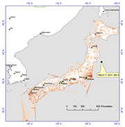
2011 9.0 Mw Tōhoku Earthquake, Japan
K.M. Cruikshank, C.D. Peterson
The purpose of this paper is to compare the strain energy released due to elastic rebound of the crust from the tragic 2011 9.0 Mw Tōhoku earthquake in Japan with the observed radiated seismic energy. The strain energy was calculated by analyzing coseismic displacements of 1,024 fixed GPS stations of the Japanese GEONET network. The value of energy (released) from the analysis is 1.75 x 10¹⁷ J, which is of the same order of magnitude as the USGS-observed radiated seismic energy of 1.9 x 10¹⁷ Nm (J) . The strain energy method is independent of seismic energy methods for determining the energy released during a large earthquake. The analysis shows that although the energy release is concentrated in the epicentral region, about 6% of the total energy was released throughout the Japanese islands at distances greater than 500 km west of the epicenter. Our results also show that outside the epicentral region, the strain-energy was concentrated along known tectonic zones throughout Japan.
Surface deformation 1994 Northridge, CA, earthquake
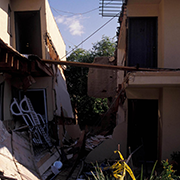
K.M. Cruikshank, Arvid M. Johnson, & Robert W. Fleming
The research will determine whether areas of concentrated damage to houses, roads and other structures can be ascribed to areas of localized ground deformation along buried faults during the 17 January, 1994 Northridge earthquake in San Fernando Valley, California. The research addresses whether localized damage is due to ground deformation as opposed to some other mechanism such as shaking in valley fill or in-phase surface waves. Our preliminary field investigations identified a zone of fracturing trending NE-SW about 100 m long in the vicinity of Tampa Avenue in Reseda, another trending NW-SE at Tampa Avenue just south of the Simi Valley Freeway, and a third at Balboa Avenue north of the Simi Valley Freeway in Granada Hills. A compilation of building damage has since suggested that the zone in Reseda is part of a band of localized damage several blocks wide and about 12 km long extending from Northridge SW through Canoga Park to Hidden Hills.
Ground deformation will be determined with pre- and post-earthquake ground surveys and aerial photographs. We will measure changes in lengths of various lines defined by connecting identifiable points such as manhole covers, fire hydrants, and other recognizable features. The strains can be obtained by comparing direct measurements of line lengths. Multiple strain measurements in a small area will allow strain ellipses to be determined at points.
Identifying the mechanism responsible for localized damage will help in formulating construction guidelines and zoning in the San Fernando Valley, and aid in planning for the occurrence of major earthquakes near the Los Angeles basin. If localized structural damage can be ascribed to surface deformation resulting from movement on buried faults, then this information will help in evaluating the seismic hazard in other areas containing buried faults, such as the remainder of the Los Angeles basin.
USGS Open-File Report 96-523 Coactive fault of the Northridge earthquake - Granada Hills, California PDF
USGS Report 96-698 Coactive fault of the Northridge earthquake - Winnetka area, California PDF
Surface fracturing and ground deformation 1992 Landers, CA, earthquake
Arvid M. Johnson, Robert W. Fleming, & K.M. Cruikshank
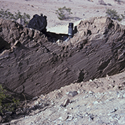
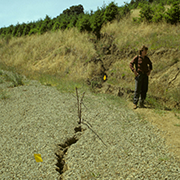
Surface rupturing during the 28 June 1992, Landers, California earthquake, east of Los Angeles, accommodated right-lateral offsets up to about 6 m along segments of distinct, en echelon fault zones with a total length of 80 km. The offsets were accommodated generally not by faults-distinct slip surfaces-but rather by shear zones, tabular bands of localized shearing. Along simple stretches of fault zones at Landers the rupture is characterized by telescoping of shear zones and intensification of shearing: broad shear zones of mild shearing, containing narrow shear zones of more intense shearing, containing even-narrower shear zones of very intense shearing, which may contain a fault. Thus the ground ruptured across broad belts of shearing with clearly-defined, sub-parallel walls, oriented NW. Each broad belt consists of a broad zone of mild shearing, extending across its entire width (50 to 200 m), and much narrower (a few m wide) shear zones that accommodate most of the offset of the belt and are portrayed by en echelon tension cracks. In response to right-lateral shearing, the slices of ground bounded by the tension cracks rotated in a clockwise sense, producing left lateral shearing, and the slices were forced against the walls of the shear zone, producing thrusting. Even narrower shear zones formed within the narrow shear zones. Although these probably are guides to right-lateral fault segments below, the surface rupturing during the earthquake is characterized not by faulting, but by the formation of shear zones at various scales.
Bulletin of the Seismological Society of America paper PDF
United States Geological Survey Open-file Report OF-93-348 PDF
USGS Open-File Report 97-153 Growth of a tectonic ridge PDF
USGS Open-File Report 97-94 Analecta of Structures Formed During the 28 June 1992 Landers-Big Bear, California Earthquake Sequence PDF
Surface deformation 1994 Loma Prieta, CA, earthquake
Arvid M. Johnson,Robert W. Fleming, K.M. Cruikshank, & Sumaryanto ("Yanto") Martosudarmo
USGS Open-File Report 97-129 Miscellaneous Maps from surface rupture from the 1994 Loma Prieta Earthquake PDF